|
Chapter 10 Supplement Images of Dar al-Hikma | ||
|
Very little remains of the palace compound
itself. Most of the palace structures, including Dar al-Hikma and Dar
al-'Ilm, are long gone. This supplement presents some images of Fatimid
Cairo buildings yet standing. Additional images are presented as location
markers.
|
||
|
||
|
Figure 10.1 pinpoints Fatimid Cairo. A rough outline of the Fatimid city wall is marked in red. (North is up, scale 1 inch : 0.4 km.) |
||
|
||
|
|
||
|
||
|
||
|
||
|
||
|
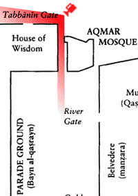
Figure 10.9 outlines the buildings of the palace compound. The Great Road to Fustat divides east and west sides of the palace. To the southeast we find Dar al-'Ilm. To the northwest, Dar al-Hikma (labeled here as "House of Wisdom"). Note that the Mosque of al-Aqmar (top center) is the only extant structure on this map. (Scale approx. 1 inch : 0.13 km.) |
||
|
The modern intersection shown in Figure 10.10 marks the location of the northeast corner of Dar al-Hikma. No ruins have been preserved. Neither has the Egyptian government afforded the site any manner of landmark. |
||
|
A series of video images provides a panorama of the intersection shown in Figure 10.10. The approximate sweep of the panorama is marked on the map in red. The panorama begins with a southward view down the Great Road to Fustat, panning westward across the corner intersection. Click on the map in Figure 10.11 to download. (QuickTime, 4.8MB, no sound.)
next Chapter 11: Passage Types | ||
|
Chapter 10 Supplement — Endnotes |
||
|
[1] Lehnert &
Landrock, Tourist Map of Cairo (Cairo: Nubar Printing House, ca. 1973).
[2] Sanders 214.
[3] Marianne Barrucand, et al., ed., Tresors
Fatimides du Caire (Paris: Institut du Monde Arabe, 1998) 66.
[4] Barrucand 41.
[5] Bayard Dodge, Al-Azhar: A Millennium of
Muslim Learning (Washington, D. C.: The Middle East Institute, 1961) 25.
[6] Sanders 213.
|
Copyright © 1999
Wayne Stewart
Last update 4/19/11


